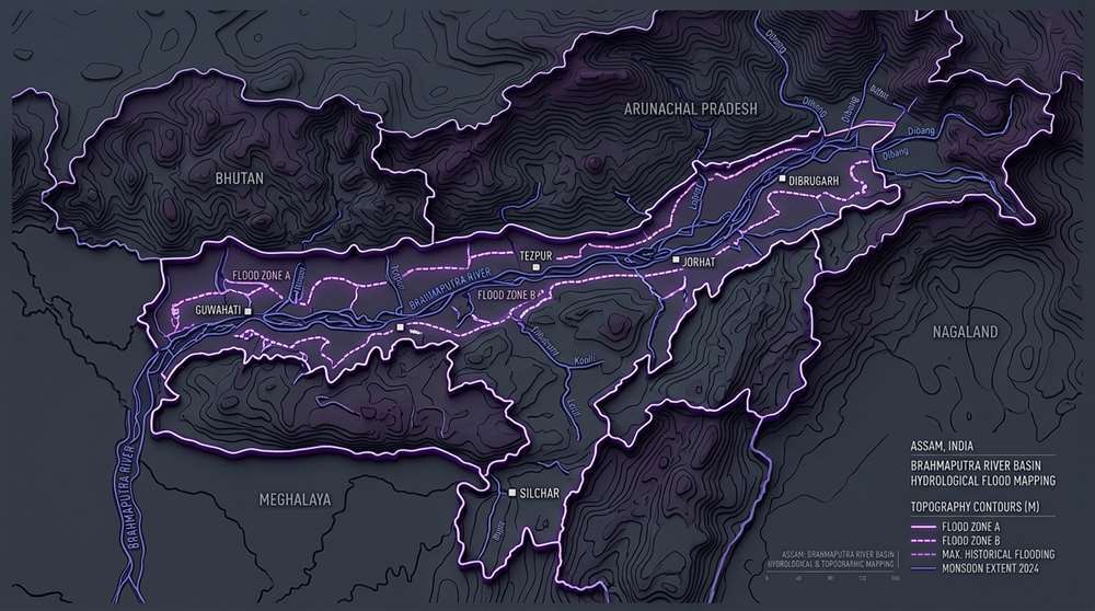
1. Imagine Living Below a River Flowing on a Silt Highway
Imagine standing outside your home in the Assam valley during the peak of monsoon season. You look toward the horizon, and instead of the river running down in a deep natural valley, the water level of the main Brahmaputra channel is actually flowing several feet higher than the ground you are standing on—contained only by an artificial earthen embankment.
This is not a dramatic scenario; it is the everyday reality for communities along the Brahmaputra basin. Every year when floodwaters submerge villages, news reports focus almost exclusively on cloudbursts, heavy downpours, and monsoon spikes. But if excessive rainfall were the sole driver, years with normal or moderate monsoon precipitation would remain completely flood-free.
In reality, devastating inundation occurs consistently regardless of annual rainfall fluctuations. The true culprit is not what is falling from the sky—it is the immense volume of silt settling at the bottom of the riverbed.
2. The Conventional Myth vs. Geological Sediment Transport
Most people assume that rivers simply carry water. In the steep Himalayan ecosystem, rivers carry massive amounts of pulverized rock, sand, and heavy sediment.
Originating in the high-altitude Tibetan plateau as the Yarlung Tsangpo, the river descends rapidly through steep, tectonically active Himalayan gorges. As the fast-moving water carves through fragile mountain terrain, it picks up immense quantities of sediment.
The moment this roaring river enters the broad, flat plains of the Assam valley, its flow velocity drops significantly. Basic fluid dynamics dictates that as water slows down, suspended heavy particles settle to the bottom. Over decades, continuous sediment deposition has progressively elevated the riverbed floor, causing the river channel to shallow and widen into a braided, unstable network.
Brahmaputra River Basin Dynamics (CWC & NRSC Satellite Data)
Continuous silt deposition progressively elevates the active riverbed level.
Overwhelms conventional earthen embankment height capacities during peak flow.
Constricts natural floodplains, increasing water velocity within narrow artificial channels.
3. The Infrastructure Dilemma: Earthen Embankments
Following historical seismic activity in the region, authorities constructed an extensive network of earthen embankments to protect agricultural lands and towns.
While embankments provided crucial short-term protection, they created an unexpected **infrastructure trap**. By locking the river between narrow artificial walls, engineers prevented silt from naturally spreading across wide floodplain wetlands during annual high-water events.
Forced to deposit its heavy sediment strictly within the narrow channel, the riverbed rose faster. Authorities responded by raising the dykes higher. Today, when an aging earthen embankment breaches under intense hydrostatic pressure, the escaping water floods low-lying villages with sudden, destructive force.
4. Practical Solutions: Managed Corridors & Wetland Sinks
Hydrological experts and disaster management planners emphasize shifting from rigid channel walls to modern, nature-aligned solutions:
- Setback Embankments: Positioned further back from the active river bank to create wide, controlled flood corridors where silt can settle safely.
- Restoring Natural Wetlands (Beels): Reconnecting degraded oxbow lakes and natural wetlands to absorb peak monsoon surges.
- Elevated Community Architecture: Promoting stilt-supported structures (Chang Ghar design) in flood-prone riparian zones.
5. The Big Picture Verdict
Assam’s flood challenge cannot be solved by fighting natural river dynamics with temporary earthen barriers. By focusing on long-term sediment management, wetland restoration, and resilient infrastructure, regional policy can build lasting geological and human safety.
NOTICE ON ACCURACY: While every reasonable effort is made to maintain factual precision, statutory rules, government notifications, and public datasets are subject to official revision over time. Content may contain unintentional errors or omissions, and readers are advised to cross-verify all regulatory information directly with primary government portals.